Does history repeat itself?
In 409 AD the British "revolted from the Roman Empire, 'rejected Roman law, reverted to their native customs, and armed themselves to ensure their own safety'" - an early Brexit? The following year (410 AD) "Emperor Honorius sends his Rescript (diplomatic letters) to the Romano-British magistrates, where he explains that the cities in Britain must provide for their own defence against the Angles, Jutes, and Saxons. This effectively ends Roman rule in Great Britain."
410 CE/AD is often described as the last year of Roman Britain, the year we entered the "Anglo-Saxon period". In fact things didn't change overnight. As with the start of the Roman era, settlement patterns and daily life evolved more slowly.
Croft and Mynard commented in their excellent book 'The Changing Landscape of Milton Keynes' - "It is clear that settlement of the area in the Roman period was extensive, so it is likely that any Saxon people entering the area would have found the remains of a well-managed agrarian landscape...It is likely that rough pasture, scrubland and even woodland had regenerated over some of the former arable lands of the villa estates. The place-name evidence in the Shenley (Bright clearing) and Bletchley (Blaecc's clearing) areas tends to confirm the wooded nature of these areas in the 7th and 8th centuries."
The map of the area did change. Magiovinium, Bancroft and other roman sites were abandoned, whilst other areas saw new development. Even places like Pennyland and the Hartigans gravel pit (near Milton Keynes village), which had seen earlier settlements abandoned in the early Roman period, saw new settlements develop. While Bancroft villa was left to decay, settlement on the hill at Blue Bridge revived.
The Saxons originated mainly in the area we know today as northern Germany and Denmark. At first they were sea-borne raiders - but in the turbulence of the collapse of the Roman Empire they began to settle. Saxon sites have been discovered in Old Wolverton, Westbury (actually in what we now call Shenley Brook End), Pennyland and Newport Pagnell. As noted above, some of our City's place names have Saxon origins. Michael Farley in his 'Illustrated History of Early Buckinghamshire' claims that "by AD 500 it is fairly likely that Buckinghamshire was to all intents and purposes a Saxon county...lacking documentation it is too early to know which principle tribal grouping (e.g. Anglian, West Saxon, etc) was dominant here." We know that they arrived holding pagan beliefs, but Christianity re-established itself during the early Saxon period. The most complete Saxon church in Buckinghamshire is to be found in Wing, between Milton Keynes and Aylesbury.
It is during the Saxon period that the "hundreds" were established. In a forthcoming post I will describe the Secklow Mound, which lies behind the Central Library in Milton Keynes.
Showing posts with label Bancroft Roman Villa. Show all posts
Sunday, 16 April 2017
The Saxons in Milton Keynes
Labels:
Bancroft Roman Villa,
Bletchley,
Blue Bridge,
Brexit,
D C Mynard,
M. Farley,
Magiovinium,
Newport Pagnell,
Pennyland,
R A Croft,
Saxons,
Secklow Mound,
Shenley,
Shenley Brook End,
Wing
Location:
Milton Keynes MK4, UK
Tuesday, 4 April 2017
The Bancroft Villa
It's nice to cycle up from our home in Furzton to Bancroft. The Redway follows the Loughton Brook, past some of the balancing lakes created to reduce flooding in that valley. Once past the concrete cows, the stream winds its way through Bancroft, with a footbridge linking to the western side - and the Roman Villa.
Fragments of Roman pottery were found by the stream fifty years ago. Major excavations took place between 1973 and 1978, directed by the Milton Keynes Archaeology Unit. Initially the site was backfilled and allowed to grass over. Then it was proposed in 1981 to create a full-size reconstruction of the villa at its most magnificent with a visitors centre and museum. Sadly these were the austerity 80s, and the ambitious plan was dropped. However further excavations were funded - covering an area of about 12,000 square metres.
The results of that excavation are set out in a two volume Monograph by R J Williams and R J Zeepat.
The earlier posts on Bronze Age and Iron Age Milton Keynes have already mentioned the settlement at Blue Bridge/Bancroft. It seems likely that the farmers there moved down the hill to the visible site of the villa. While the foundations of the main building are visible, the outbuildings lie buried underneath the open space between the roman remains and the pétanque piste to the north.
Where the Bronze and Iron Age settlement lay, a mausoleum was built. It continued in use, probably until the villa itself was abandoned in the fourth century CE (AD).
There are some excellent interpretation boards by the main villa building. The site was developed from the early years of the first century. We believe that the first farm (villa) on this site was constructed in the late first century. This was occupied until a fire destroyed mainly of the buildings in about 170 CE (AD). A large Roman style house was was built in the late third century - but there is no evidence that it was a farm. It was in the fourth century that the villa reached its full extent and glory. Clearly its inhabitants had become very prosperous.
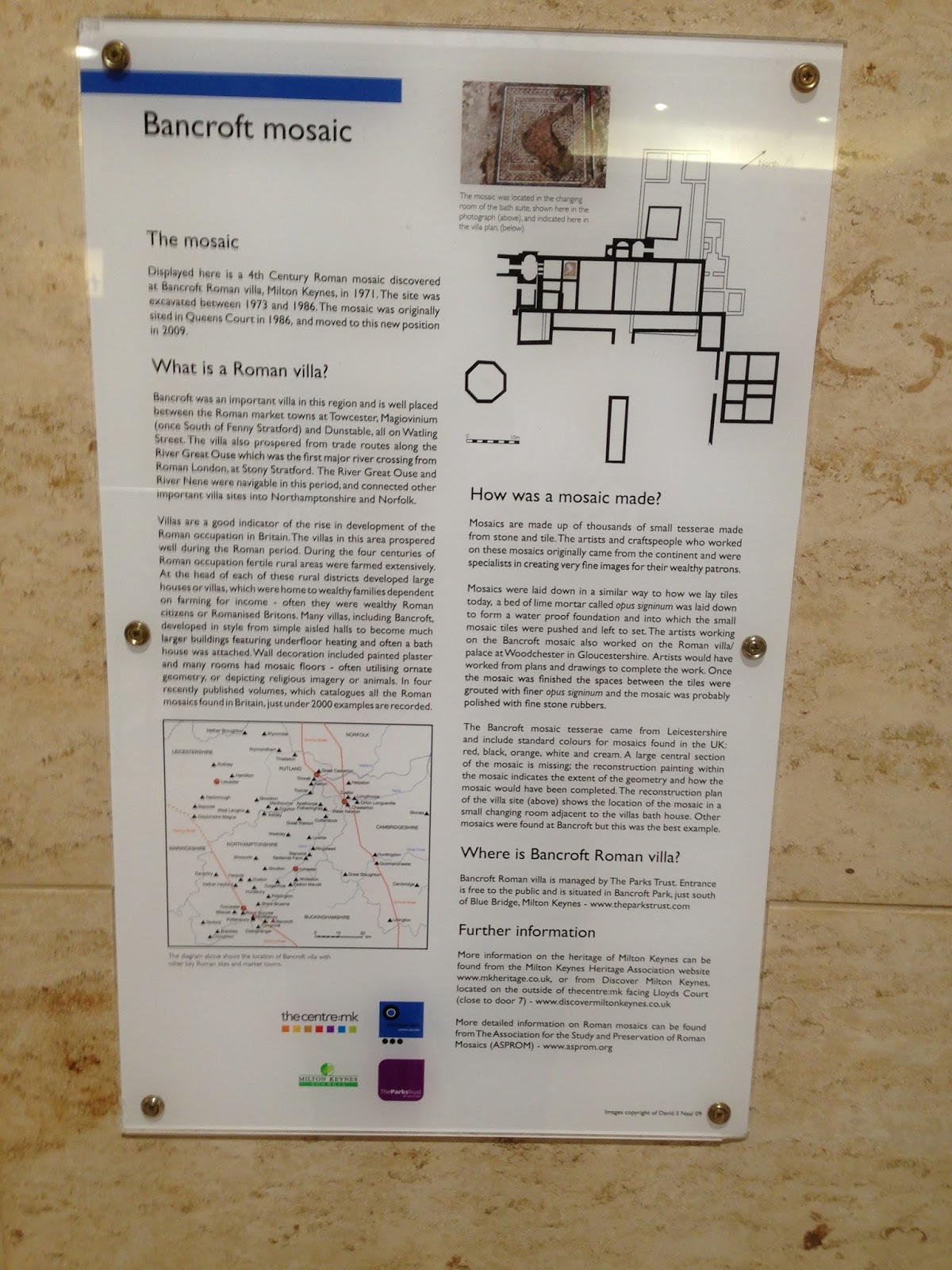
The main residential building was decorated with mosaics. One of these is currently on display in the Milton Keynes shopping area (Centre:mk) - close to the toilets in Deer Walk (Entrance North 9). In front of the villa is a fishpond - and the room layout is explained on the interpretation boards and can be seen on the ground.
Fragments of Roman pottery were found by the stream fifty years ago. Major excavations took place between 1973 and 1978, directed by the Milton Keynes Archaeology Unit. Initially the site was backfilled and allowed to grass over. Then it was proposed in 1981 to create a full-size reconstruction of the villa at its most magnificent with a visitors centre and museum. Sadly these were the austerity 80s, and the ambitious plan was dropped. However further excavations were funded - covering an area of about 12,000 square metres.
The results of that excavation are set out in a two volume Monograph by R J Williams and R J Zeepat.
The earlier posts on Bronze Age and Iron Age Milton Keynes have already mentioned the settlement at Blue Bridge/Bancroft. It seems likely that the farmers there moved down the hill to the visible site of the villa. While the foundations of the main building are visible, the outbuildings lie buried underneath the open space between the roman remains and the pétanque piste to the north.
Where the Bronze and Iron Age settlement lay, a mausoleum was built. It continued in use, probably until the villa itself was abandoned in the fourth century CE (AD).
There are some excellent interpretation boards by the main villa building. The site was developed from the early years of the first century. We believe that the first farm (villa) on this site was constructed in the late first century. This was occupied until a fire destroyed mainly of the buildings in about 170 CE (AD). A large Roman style house was was built in the late third century - but there is no evidence that it was a farm. It was in the fourth century that the villa reached its full extent and glory. Clearly its inhabitants had become very prosperous.
The main residential building was decorated with mosaics. One of these is currently on display in the Milton Keynes shopping area (Centre:mk) - close to the toilets in Deer Walk (Entrance North 9). In front of the villa is a fishpond - and the room layout is explained on the interpretation boards and can be seen on the ground.
Saturday, 25 February 2017
Books on Milton Keynes History
There are some excellent books to be found in Milton Keynes libraries (and not just the local studies section in the Central Library) – about the history of the city.
I’m currently borrowing (fear not, there are multiple copies) – three excellent books – which are aiding my research. I will be putting the results up on this blog.
The three books are
The Changing Landscape of Milton Keynes – R A Croft and D C Mynard.This has a chapter by R J Zeepvat on the geology and topography of this area – an essential for understanding our city’s past and present; Descriptions of the area at different periods. [Prehistoric; Roman; Saxon; Medieval and Post-Medieval]; a chapter by M Gelling on place-names of the Milton Keynes area. It concludes with a series of parish essays – focusing on discoveries made in the old parishes of our city.
Roman Milton Keynes: Excavations & Fieldwork 1971-82 – edited by Dennis C Mynard. It has some excellent maps; drawings and lists of finds. There are also a set of photographs.
Excavations on Medieval Sites in Milton Keynes – also by Dennis Mynard in the Buckinghamshire Archaeological Society Monograph Series. This too has some excellent diagrams & drawings; photographs and descriptions of the major sites.
I have my own copies of two excellent books – R J (Bob) Zeepvat’s “Roman Milton Keynes” which has chapters on Iron Age Background; The Roman Occupation; Roman Government; Towns; Communications; Countryside; Villas; Trade & Industry; Religion and Burial – and Further Reading.
and “An illustrated History of Early Buckinghamshire” edited by Michael Farley – which describes the area and puts it into a wider context.
Tuesday, 21 February 2017
Milton Keynes History
Last month the city of Milton Keynes celebrated its 50th birthday - but the area has much of historical interest. It is overlooked by the iron-age fort of Danesborough, includes the Roman settlement of Magiovinium, a Roman villa, the historic Watling Street coaching town of Stony Stratford, Bletchley Park and transport routes from across the ages (Watling Street, Grand Union Canal, Railway, M1). It includes a number of ancient villages and the historic towns of Bletchley, Stony Stratford, Wolverton and Newport Pagnell.
In this and subsequent posts, I will share something of that history. There is an excellent map called "Milton Keynes Heritage". I believe that it may still be available from the Visitor Information Centre in Centre:MK [the huge indoor shopping centre]
I've always believed that to understand the history of an area, it is necessary to study its geography. Milton Keynes is built on a low plateau, crossed by three rivers.
The biggest river forms the Northern boundary of the city itself, then crosses through some of the rural parts and through the town of Newport Pagnell. The Great Ouse runs 143 miles from its sources in Northamptonshire (near the village of Syresham), through Brackley, Buckingham, Milton Keynes, Olney, Bedford, St Neots, Huntingdon, St Ives and Kings Lynn before entering the Wash. The Treaty of Alfred and Guthrum - which settled the border between the Anglo-Saxon kingdoms and Danelaw ran along the Great Ouse between Stony Stratford and Bedford.
The second river is the Ouzel (also known elsewhere and in other eras as the Lovat). It rises not far from Whipsnade Zoo - and flows through Leighton Buzzard and through the city close to the site of Magiovinium; past the Open University, meeting the Great Ouse in Newport Pagnell.
The third 'river' is a brook - but it has carved out a pleasant valley which is partly used by the railway. Loughton Brook rises a little outside the City to its south west. It flows through the estates of Tattenhoe Park, Tattenhoe, Emerson Valley, and Furzton - where it feeds Furzton Lake, past the Milton Keynes (National) Bowl, Knowlhill (where the Teardrop lakes are), Loughton, past Bradwell Abbey and close to the Roman Villa in Bancroft, eventually meeting the Great Ouse in New Bradwell.
In this and subsequent posts, I will share something of that history. There is an excellent map called "Milton Keynes Heritage". I believe that it may still be available from the Visitor Information Centre in Centre:MK [the huge indoor shopping centre]
I've always believed that to understand the history of an area, it is necessary to study its geography. Milton Keynes is built on a low plateau, crossed by three rivers.
The biggest river forms the Northern boundary of the city itself, then crosses through some of the rural parts and through the town of Newport Pagnell. The Great Ouse runs 143 miles from its sources in Northamptonshire (near the village of Syresham), through Brackley, Buckingham, Milton Keynes, Olney, Bedford, St Neots, Huntingdon, St Ives and Kings Lynn before entering the Wash. The Treaty of Alfred and Guthrum - which settled the border between the Anglo-Saxon kingdoms and Danelaw ran along the Great Ouse between Stony Stratford and Bedford.
The second river is the Ouzel (also known elsewhere and in other eras as the Lovat). It rises not far from Whipsnade Zoo - and flows through Leighton Buzzard and through the city close to the site of Magiovinium; past the Open University, meeting the Great Ouse in Newport Pagnell.
The third 'river' is a brook - but it has carved out a pleasant valley which is partly used by the railway. Loughton Brook rises a little outside the City to its south west. It flows through the estates of Tattenhoe Park, Tattenhoe, Emerson Valley, and Furzton - where it feeds Furzton Lake, past the Milton Keynes (National) Bowl, Knowlhill (where the Teardrop lakes are), Loughton, past Bradwell Abbey and close to the Roman Villa in Bancroft, eventually meeting the Great Ouse in New Bradwell.
Labels:
Bancroft Roman Villa,
Bletchley,
Bletchley Park,
Danelaw,
Great Ouse,
Loughton Brook,
Magiovinium,
Milton Keynes,
Milton Keynes Visitor Information Centre,
Newport Pagnell,
Ouzel,
Stony Stratford,
Wolverton
Location:
Milton Keynes MK4, UK
Friday, 20 May 2016
Milton Keynes History
Does Milton Keynes have any history? The general impression of Britain's newest city is that its "history" only covers the last 50 years. In fact, nothing could be further from the truth. As well as making an excellent base for discovering key sites in British History (fast rail link to London - and the slower trains stop at Berkhamsted : almost the mid-point between Oxford and Cambridge ; Close to Buckingham and Aylesbury) - MK has plenty to see within its boundaries.
Now known across the world - Milton Keynes is where Bletchley Park is to be found. Perhaps you've seen the film "The Imitation Game"? Some of it was filmed there - but if you visit you can see Alan Turing's office - and the mansion itself.
The Roman road which we now know as "Watling Street" runs through the city. In fact it runs at the end of Furzton - and through the town of Stony Stratford. There are the remains of a large Roman villa in the estate of Bancroft (which I love visiting) - not very far from the concrete cows. Other villas have been unearthed as archaeologists gained the opportunity to discover the city's ancient history before the developments went ahead. I live just yards from an iron age settlement and bronze age; iron age; Roman; and medieval remains have been uncovered across the city.
When Edward IV died, the crown was inherited by his young son. It was in Stony Stratford that he was met by his uncle, who was to become Richard III, and taken into "protective custody". A sign on a house commemorates where
they met. Stony itself is full of historic buildings.
The area played a key role in the transport history of England - and as well as a Roman road; there is the canal and the railway. Wolverton works was an important place for building and repairing railway stock.
The villages that sat in the countryside which was used for the new city remain - though are hidden from the hidden roads. Loughton; Milton Keynes (the original village); Shenley Brook End and Shenley Church are just some of the delights to be discovered.
Newport Pagnell played an important role in the English Civil War of the Seventeenth Century.
Over this summer I will be revisiting many of these places - and along with book research - will have lots of materials to post on this blog.
Now known across the world - Milton Keynes is where Bletchley Park is to be found. Perhaps you've seen the film "The Imitation Game"? Some of it was filmed there - but if you visit you can see Alan Turing's office - and the mansion itself.
The Roman road which we now know as "Watling Street" runs through the city. In fact it runs at the end of Furzton - and through the town of Stony Stratford. There are the remains of a large Roman villa in the estate of Bancroft (which I love visiting) - not very far from the concrete cows. Other villas have been unearthed as archaeologists gained the opportunity to discover the city's ancient history before the developments went ahead. I live just yards from an iron age settlement and bronze age; iron age; Roman; and medieval remains have been uncovered across the city.
When Edward IV died, the crown was inherited by his young son. It was in Stony Stratford that he was met by his uncle, who was to become Richard III, and taken into "protective custody". A sign on a house commemorates where
they met. Stony itself is full of historic buildings.
The area played a key role in the transport history of England - and as well as a Roman road; there is the canal and the railway. Wolverton works was an important place for building and repairing railway stock.
The villages that sat in the countryside which was used for the new city remain - though are hidden from the hidden roads. Loughton; Milton Keynes (the original village); Shenley Brook End and Shenley Church are just some of the delights to be discovered.
Newport Pagnell played an important role in the English Civil War of the Seventeenth Century.
Over this summer I will be revisiting many of these places - and along with book research - will have lots of materials to post on this blog.
Labels:
Bancroft,
Bancroft Roman Villa,
Bletchley Park,
Edward IV,
Edward V,
Loughton,
Milton Keynes village,
Richard III,
Stony Stratford,
Wolverton,
Wolverton Works,
Woughton
Location:
Furzton, Milton Keynes, UK
Subscribe to:
Posts (Atom)